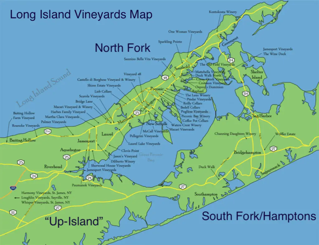
Map of North Fork Long Island
Are you are looking for a Long Island Vineyards map? This map of North Fork Long Island will hopefully be what you are looking for!
The North Fork of Long Island is located on the eastern part of Suffolk County. It’s called the North Fork becuase the island spilts in two on the East End. The South Fork, or Hamptons is other fork of the split. In the middle of the two forks is Shelter Island and Gardiner’s Island (private).
The South Fork and western parts of Long Island have a number of wineries and vineyards. However, the North Fork has the vast majority of them, as you can see in this Long Island Vineyards map!
Long Island is a big place, so here’s a Long Island map to help you understand where the East End lies.
Long Island has some wonderful wineries to visit. Some even offering some great food to go along with that wine! There are even a cluster of breweries to visit, too.
The vineyards and wineries have sprouted up from potato and corn fields over the past 40 or so years. The wines are becoming more refined and more well-regarded with each year’s vintage.
There are so many working farms, farmsteads, restaurants and more on the North Fork and Hamptons. It’s a beautiful, bucolic, and really fantastic place to visit!
The number, names, and sizes of the wineries and vineyards change often. I will try to do my best to keep this map as current as possible. Forgive me if I miss some updates!
Things To See and Do on the South Fork
There are so many amazing houses things to do on Long Island! I always recommend seeing as much of the South Fork as possible!!
The Hamptons and Montauk is a world-renowned beach resort destination for good reason! There is just so much to see, do, and enjoy! Here are just a few of them:
Check out this Guide to the Best Beaches in Montauk! Also, check out this Guide to The Hamptons best beaches!!
Check out some luxury homes in The Hamptons!
Maybe you will love it so much, you’ll want to check out some Hamptons wedding venues!
Enjoy some of the world-class, amazing art in The Hamptons!
Check Out More Long Island Wine
You’re so close to Long Island Wine Country! It’s another great part of visiting the island. If you’re in the mood for great wine, be sure to check out our Complete List of Long Island Wineries and Long Island Vineyards.
Check out the absolute best Long Island Wine Tours!
If you can’t make it to a tour, why not do some wine tasting at home with Bedell Cellars!
I know you’re getting hungry, so be sure to also check out the best wineries on Long Island for some great food!
While you’re in the area, be sure to check out these 9 relaxing things to do in the North Fork!
When you’re done with all of this wine drinking and relaxing, how about making it a weekend? Here are 10 great North Fork Long Island hotels to enjoy as well.
While You’re Enjoying the Outdoors
Be sure to find out about more things to do on Long Island as well as more great spots to eat and drink and wonderful places to stay on Long Island!
Check out this guide to Long Island driving ranges, including this feature on the popular Heartland driving range! Go have fun at one of these great Long Island skate parks!
Make It A Weekend
The East End of Long Island is a really special spot. If you think you’d want to check it out and maybe even stay awhile…that wouldn’t be such a terrible idea.
If you wanted to consider different options for staying on Long Island, be sure to check out these great places to stay in Montauk, 11 Hamptons hotels, 10 North Fork Long Island hotels, and this Guide to Sag Harbor hotels! Enjoy reading up on and hopefully exploring these wonderful Shelter Island hotels and let me know if you decide to make it a vacation!
More From The Long Island Local
Maybe grab a freshly brewed beer at these Long Island breweries and when you’ve had your fill of vino! I mean, after a day of searching for the best tacos on Long Island, I think you need a drink, no?
The bounty of great food on Long Island seems endless! From great steakhouses on Long Island to great Shelter Island restaurants to Long Island lobster rolls and Long Island bagels, there’s so much to enjoy. Check out this Huge List of Restaurants on the Water Long Island!!! How about 54 of the best tacos on Long Island!
And how about all the wonderful Wölffer Estate Vineyard events and tastings?! Or maybe check out some Long Island oyster farms! How about these guides to Long Island Coffee Shops and Long Island coffee roasters!! Check out these 16 Long Island Boardwalks! Take the ferry over and enjoy these Fire Island restaurants! Let’s not forget about the best tacos on Long Island and these great Long Island pizza places either!!
Be sure to find out about more things to do on Long Island as well as more great spots to eat and drink! Maybe take a stroll in one of these amazing Long Island arboretums and gardens! There are even this great Long Island kayaks and paddleboard guide to exploring!